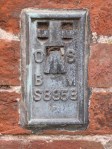
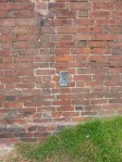
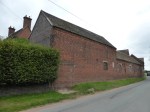
August 30th – Out for an afternoon spin, I came through Wall, just south of Lichfield. Just as I was approaching the junction of the old Watling Street and Wall Lane, I noticed that on the side of the old barn at Manor Farm, there was an Ordnance Survey Flush Bracket. This is a type of benchmark that was used for map surveying – in the notches on the plate, surveying equipment could be mounted at a height known to the surveyor, called a Datum, or benchmark. The flat tip of the arrow indicates the precise height point, and this is benchmark reference S8958.
I must have passed this wall hundreds of times and have never noticed this feature.
