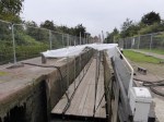
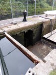
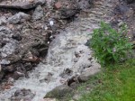
September 23rd – The Birchils lock flight in Walsall is currently closed and mostly drained for maintenance. It’s interesting to see the pounds drained, and how much junk accumulates in them. Also the simple technology of damming the water to allow work to take place. Some flow still accrues due to overspill, and I was impressed with how clear and clean that was, and I noted how it had cut down to the clay liner – the ‘puddling’ – that keeps the canal water from soaking into the earth.

I don’t know how long the work will go on for, but it’s nice to see the locks being maintained.

September 8th – This is a relic of a different time, and most people never, ever notice it. This barcode sign, fixed to a lamp post on the Chester Road in Brownhills, just down from the Shire Oak, is a remnant of a system devised in the the eighties and implemented in the nineties for automatically assessing road maintenance. Surveying vehicles would drive the roads, checking the surface, just as they do now, but in the absence of cheap, accurate GPS, onboard systems looked for markers like this. Upon registering one, the recorder then reset a distance counter. The marker sign was read automatically, and the location of a defect being recorded by the distance from the last marker seen. Thus repair vehicles could locate faults the same way. Each sign gave a unique number. The whole network was obsolete in less than a decade, but the signs remain, puzzling anyone who notices them.