July 22nd – A fast, enjoyable 50 mile ride on an afternoon bunked off work saw me calling at Barton and then Rosliston for excellent carrot cake on a hot, sunny day. On the way, I took in a little of the canal near Barton Marina, and spotted the benchmark in the bridge just by Barton Turn. I think that’s the first I’ve ever seen highlighted with paint and it also seems rather high.

It must be genuine, but I sense a story here. Any ideas?

Apriul 12th – I must have passed this hundreds of times without noticing it. Facing the footpath on the Birmingham Road, just on the edge of the Highwayman Car Park at Shenstone Woodend, this Ordnance Survey monument. Cast Iron, now at a jaunty angle, it sows a benchmark in the absence of a building to carve one into.

I had no idea these ornate cast iron ones existed, and they seem relatively rare. A fine, uniquely British thing.

August 30th – Out for an afternoon spin, I came through Wall, just south of Lichfield. Just as I was approaching the junction of the old Watling Street and Wall Lane, I noticed that on the side of the old barn at Manor Farm, there was an Ordnance Survey Flush Bracket. This is a type of benchmark that was used for map surveying – in the notches on the plate, surveying equipment could be mounted at a height known to the surveyor, called a Datum, or benchmark. The flat tip of the arrow indicates the precise height  point, and this is benchmark reference S8958. 

I must have passed this wall hundreds of times and have never noticed this feature.

August 22nd – near the top of Mere Hill overlooking the Manifold Valley near Calton in the Peak District stands this old, redundant stone gatepost. Initially, its survival long after the field boundary it marked was removed is puzzling, until one notices the Ordnance Survey surveyor’s benchmark carved into it. This is the usual explanation for any such stone posts, and the majority are no longer used, but it does make a fine cattle scratching-post.

October 10th – I’ve been studying the detail of buildings lately. Small things. Architraves, chimneys, corbels, pediments, lintels. Airbricks, panels and frescos. Sills, doorways and sashes. There’s a huge variety of stuff in the everyday. In a quiet Tyseley backstreet, my gaze was caught by this ornate ventilation brick made from pressed terracotta in an otherwise plain factory wall. As I stopped to take a better look, I noticed the Ordnance Survey benchmark carved into the wall. A fixed datum at a measured height, these may not be used so much now, but they’re a real signal of permanence. 
The things you see with your eyes open… 

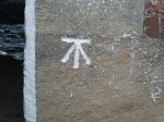
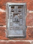
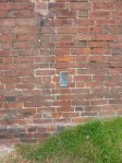
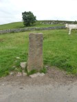
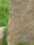
May 7th – The odd symbol on this markerstone will be familiar to many who study old buildings, but it’s purpose is not widely understood. It’s a surveyor’s benchmark, used by Ordnance Survey mapmakers. The horizontal bar at the top of the mark indicates a known, measured height above mean sea level, which the surveyor will know and can then use to reference other measurements. Benchmarks can exist anywhere, but are easily spotted on churches, bridge abutments and stone gateposts. Sometimes, as in this case by the A51 near Whittington Golf Course, a stone is placed for the purpose. These are a secondary reference to trig points. It is actually an offence to remove or obscure one.

In the days of new technology such as global positioning and satellite imagery, benchmarks are not as commonly used as they once were, but every surveyor that works for the OS is still taught to carve them. They are a tangible, visible footprint of the gorgeous heritage of British map-making that the Ordnance Survey represents.