5th September – At the top of Digbeth High Street in Birmingham, one of about 130 or so left.

Highly unusual, it captures a fleeting moment in British history. Been meaning to feature this for some time – and it’s not the only one in Brum, either.

A fine bit of British quirkyness on a fun afternoon.

August 21st – A grey and depressing day with a heavy, punishing wind. On my way home, for a change, I rode over Springhill and Barracks Lane down to the Lichfield Road, and came into Brownhills that way. 

On the crossroads of Barracks Lane and Lichfield Road, what I think must be one of the oldest buildings in Ogley Hay and wider Brownhills; Warrenhouse Farm’s barn.

Now converted into a dwelling, I’m sure parts of this stone and brick structure are very old indeed; the farm here was where the Warren Keeper lived, who kept the rabbits on Ogley Hay for hunting – hence the Warrener’s Arms pub. Another noted resident was William Roberts, who tried to retire here, but found it too quiet and he soon returned to the bright lights and bustle of Brownhills.

These days, Warrenhouse is no longer a farm; it is private houses and a noted veterinary surgery, but this was the closest building to the location of the Staffordshire Hoard, found only a couple of hundred metres away, and is therefore evidence of a much earlier time, before Brownhills itself.

The converted barn has some lovely flowerbeds running around it too; such a delight on a grey day. 

May 13th – The purple lupins (always earlier than the pink ones) are coming out on the canal bank above the big house at Clayhanger. I’ve never been sure if these are truly wild, or long-time feral escapees from the long gone garden of Ernest Jones, who had tennis courts and delicate flowerbeds at the foot of the embankment here nearly a century before. 

They are beautiful, complex and fascinating, and yet anotherindicator of the seasons escapement clicking over another notch. Spring goes from whites and yellows to blues and then purples. Summer is pretty much upon us now.

April 18th – A great long ride today, on a warm, wonderful spring day. I headed out to Honey Hill, at No Man’s Heath via Canwell, Hints, Hopwas and Harlaston, returning via Netherseal, Lullington, Edingale and Lichfield. On the way, I stopped, as I always do, at the old ROC post at Harlaston. It was still in a very sorry state, but I was reminded of something. 

Stopping for a drink and a breather at the top of Willowbottom Lane, just by the bunker, I looked down and noticed a barely visible square of bricks and concrete. This is another reminder of past conflict, for these are the remains of a second world war anti-aircraft watchpost.

High on the hill above Tamworth, it’s an excellent spot for it. A sobering thing on a sunny, spring afternoon.

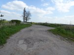
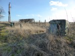
February 16th – As I passed from Elford to Harlaston, I stopped as I usually do, to check out the state of Harlaston ROC post. What I saw saddened me, as it continues to deteriorate.

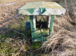
These odd green surface structures are the visible evidence of a small, 3-man nuclear fallout shelter. Intended to be staffed by a group of volunteers from the local Royal Observer Corps, they were a state secret. Should nuclear conflict have begun, the crew would man this subterranean bunker equipped with basic recording equipment, water and rations, and take measurements of radiation, weather, fallout, bomb damage and soforth. This information would be relayed – if possible – through telegraphy equipment installed within. Posts were sited all over the country, and worked in groups of 3. Others existed locally at Polesworth, Rugeley and Shenstone.

In essence, should the Cold War have begun, three people would have entered this hole in the ground, and if they didn’t perish, they would have carried out their orders whilst waiting to die of radiation sickness. It’s a sobering thought.

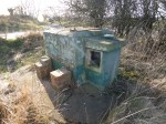
The posts – and the Royal Observer Corps – were stood down at the end of the Cold War in the early 1990s, and the posts mostly left to rot. Some were preserved by enthusiasts, some bought by cellphone companies – they make great basetation mounts – but the majority were abandoned, and later discovered in the internet age by urban explorers and cold war enthusiasts.

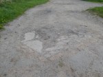
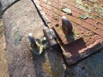
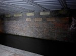
Sadly, the bunkers were left filled with all their equipment – bedding, instruments, lockers, chemical toilets and whatnot – and have mostly now be broken into, stripped and vandalised. Harlaston has been systematically destroyed. The current owner has repeatedly welded the access shaft shut, only to have it continually cut open. When I visited, there we signs of fresh cutting and the hatch was unlocked.

This is a crying shame. This is part of our collective history, destroyed and desecrated by animals with no sense of the historic and social significance.

High on a hill overlooking this northeast outpost of Staffordshire, good folk would have entered this once immaculate shelter to serve us in our time of greatest darkness. Today, it’s trashed.

Scum.

February 5th – I know little about this, and although peripherally aware of the Aldridge Garden of Reflection for some time (if that’s the right name), I’d never stopped to look. Today, passing through the town on my way home, I stopped to check it out.

On the corner of the High Street and Little Aston Road is a small, landscaped and sculpturally paved area with benches, flowerbeds and decorative friezes in the paving. It’s very sweet, and a little oasis. The reliefs in the paving relate to aspects of Aldrige life – history, present and so forth. There’s an interesting large compass too, pointing out the nearby major landmarks. Overall I was very impressed.

Not sure who was behind this, although Aldridge Rotary Club are mentioned. I must find out more about it.

I wish I’d stopped to look here sooner…

December 27th – I was out taking photos for the New Year Quiz on the main blog, and I found myself in Engine Lane (no, this isn’t a clue!) as the sun set. The green lane here is nothing but a mud bath, but it was beautiful, all the same. Considering the filth and fury that would once have existed here in the form of mining, it really is hard to imagine the peace of this quiet, almost rural spot ever being disturbed; likewise, the canal between Clayhanger and the Black Cock Bridge. Where I stood, trains once crossed to a huge colliery on the other side of the canal. The air would have been full of smoke, dust and noise; the canal full of narrowboats.

As the sun set on this very, very windy but quiet afternoon, it was hard to visualise the industry that made this community.

How time moves on.

December 21st – For now of course, the night is still perched upon my journeys. I came back from Chasewater along the canal in the dark, hoping to have another fiddle with long exposures – but the absence of moonlight and a wind that shook the camera made my attempts useless. Heading to Catshill Junction and Clayhanger Common, I passed under Anchor Bridge.

Barely noticeable to the non-locals who pass over it every day in their cars, it’s an interesting structure, the abutments and brickwork still bear witness to an older, narrower structure. I noted this as my light caught the brickwork. The wonderful local historian Gerald Reece had pointed this out to me in an email last year, and I’d meant to record it. Spinning on to Catshill junction, I noted also the road alignment rejoining the canal contour.

It’s rare to see a bridge so well accommodated into its surrounding landscape.

July 16th – I noticed something today that’s puzzling me. I doubt many others have ever registered it, and even fewer probably care, but it appeals to my sense of lost history. I noticed today that Tyseley Station once had a lift, or at least, the evidence points to it.

I noticed some time ago there was a tower attached to the station building, contemporary with the rest of the structure, that had no apparent door or way in. It’s a few metres taller than the main building, and is about the size of a lift shaft, but there’s no evidence of it in the booking hall, where the tiles and fittings look original and undisturbed from new.

Down at track level on platforms 1 & 2, there is a low, bricked up doorway with a modern door built in. The platform island ramps down to it. It’s the only access to the tower I can see.

At pavement level, three sides of the tower are plain, and blank (the terracotta paint is covering graffiti, note the continuous texture of the brickwork underneath) – the other side of the tower can be seen in this image series from last week.

I do hope some passing railway buff can help with this. Was it a lift? If so, why? What did it convey? Who used it?

It’s an odd little mystery all of it’s own.