July 21st – It’s true that I am one of those characters that amasses a huge amount of trivia and mental flotsam as I go about daily life, and this is one of those things, but in my defence, I was actually asked about this a month or so ago so here you go…

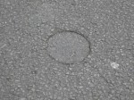
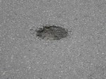
People who study the road surface (and there are a few of us, mainly on 2 wheels) may notice perfectly circular cutouts, punch-throughs or holes in the endless asphalt. Sometimes they’re filled with tar, or white lining paint. Often, they have the material that came out of them put back in like a tarmac divot. Sometimes, they open into potholes, particularly if badly sealed. But what are they?

These odd features are the signature of the road surveyor, and a road near the end of it’s life. When a road is resurfaced, the tarmac is literally planed off by a large cutting machine. The planings are then taken away, recycled back into asphalt, and relaid. How deep that planing operation goes is critical, as is knowing the depth of the road surface, and what it’s like beneath the blacktop ‘crust’.

When a road is considered for resurfacing, a surveyor will take cores with a drill and round cutter at about 100-125mm diameter, and extract them like a cheese taster sampling a cheddar. They are photographed, measured and replaced (or filled). From this a plan of work can be formulated.

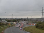
Sometimes cores are taken in pairs, close together; others they are equally spaced along the length or a road, on either side. These, spotted around Walsal today, are in various states of becoming potholes themselves and adding to the problem they were created in the process of alleviating.

I’m convinced that every time I learn rubbish like this, it pushes something useful out of the back of my brain.

August 19th – First really wet commute in ages, and the rain wasn’t cold, so it wasn’t particularly unpleasant. The traffic, though, lulled into the forgetfulness it normal befalls in summer, wasn’t so pleasant. 

I hate the way summer rain seems to make drivers behave so oddly. I was glad to get home.

April 30th – This was a shock – I cycled to work for a change up the canal through Walsall Wood. Just past Clayhanger bridge, at the back of Maybrook Industrial Estate, a small group of female red deer (still very much in moult, the poor scruffy things) were browsing the scrub. This is an isolated patch only really accessible from nearby roads, but in itself, although small, is not bad for them as it’s barely touched by humans.

This means the deer are now crossing Clayhanger Bridge. 

Watch out on the roads, folks.

December 18th – a half day, and chance to nip on an errand to Whittington. The weather was horrid – drizzly, hot and very windy, so I wound my way through the backlanes of Shenstone and Weeford. Heading up Jerrys Lane, i stopped to look east over the A5 bypass to Tamworth. One of the few decent road projects to spin off the M6 Toll, it has cured the traffic issues on the nearby old A5 and A51 beautifully. 

I rode on this just before it opened, but never took any photos. I wished I had – the views from the brow of Rock Hill over Tamworth are extraordinary, particularly at night. But this road is more of a motorway than the M6 Toll, and I wouldn’t dream of cycling it now.

October 15th – I passed through Churchbridge on the A5 between Cannock and Great Wyrley. This is a horrid, horrid landscape; there is no accommodation within it for pedestrians or cyclists, who do battle with it rather than inhabit it. The architecture and urban design is on a massive, non-human scale which dwarfs pre-existing houses and even the the electricity pylons.

This is not a place for those without a car. An utterly discriminatory piece of urban engineering. I hate it with a passion.

June 22nd – Riding (unusually for me, it’s a long story) up the A460 through Rugeley, I spotted this bit of arsehattery masquerading as cycling infrastructure. This is a ‘mandatory’ cycle lane, as indicated by the solid white line. Mandatory in this context means it doesn’t have to be used by the cyclist, but that traffic shouldn’t occupy it or park in it. 

So far so good.

So they run it close to an oblique parking bay, on the left. What could possibly go wrong? 

What’s wrong with this picture, kids? 

January 10th – Time for another cycling tip. This is one I repeat often, and is very important, so it bears repeating. Following the rain we’ve had, the roads are currently filthy. This isn’t just country lanes, but major roads, too; the Chester Road up to Shire Oak from Stonnall northbound has a band of wet silt stretching nearly a metre from the kerb for several hundred metres, and it’ as slippery as hell. In the country lanes, the wash down has deposited grit, marbles and hedge-flailings containing sharp thorns into the road, right where we cyclists normally ride..

Watch where you’re going. Beware of puddles that could hide deep potholes. Corner carefully, and maintain your space on the road, so you have somewhere to move to if an unseen hazard appears. Carry spare tubes or a means of repair.

Take it steady out there, folks.

November 23rd – I was passed by a grit lorry on the Chester Road, and winced as the rocksalt tinkled off my bike. It is winter now in all but name, and I’ll get used to it. The cold was bitter, and frost was on the way, so it was good to see Walsall Council teams out on a Saturday treating the roads. As I passed the back of the depot at Apex Road, the yard was busy loading lorries as they came in, and I noted that the salt barn was pretty much full, all set for the winter ahead. A sobering thought.

July 7th – Oh my goodness, this is geeky. But it appeals to my sense of the absurd. This road sign on the ‘old’ A5 near Mile Oak isn’t unique, but it’s certainly rather unusual. What makes it so is not the restriction and advice it gives, but the accidental inclusion of the road number C0036. Just about every road in the UK has a number to the Ministry of Transport (or whatever it’s called these days) and to the local authority, but in theory, only the familiar A and B class roads are allowed to be marked on signage.

There are, actually, five classes of road – A through D, in order of major to minor, and U, meaning unclassified, even though they actually are. Maps for public consumption only use A&B, and the remaining numbers are intended for administrative use only, but occasionally, in cases such as this, due to CAD or administrative errors, a C or D number will creep on to a sign.

This one has been in place since the bypass was built, a good few years ago now, and always raises a wry smile.

April 8th – It’s that time of year again. Following the big freeze, potholes and fissures open up in the roads. This is a normal process caused by wear, and the hydraulic shearing action of water under vehicle tyres. I notice many main roads have suffered this year – maybe worse than the side routes. Here at Lichfield Road, Sandhills, ice seems to have lifted and crazes the tarmac, which has broken down to grit – itself dangerous to the incautious cyclist.

Report anything like this directly to the appropriate council using http://www.fixmystreet.com – it’s free and surprisingly effective.