January 16th – As much as I’m growing to loathe the results of the renovation of New Street Station in Birmingham, the process is still fascinating me. One of the things I like about it is how normal conventions of public buildings are broken. There is serious civil engineering going on at the same time as huge numbers of people and trains pass through this humming interchange..

Odd things happen.

Personnel appear from hidden doorways and gaps. There are odd noises and bangs. Occasionally, you get sprayed with water, or dust. Lifts and stairs appear, and then are boarded up again. cables dangle and tangle above the headspaces, and snake and race through the girders and scaffold.

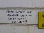
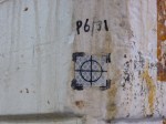
One of the things you see here you don’t elsewhere is engineering graffiti. Surveyors measure. Sparkies test. Cladders clad. All of them leave their marks and datums scribbled on walls, floors and hoardings. Sometimes, they make sense. Often, they’re just mysterious glyphs, whose purpose is only known to those with the skill. I love how they ebb and flow with the focus of the work.

Spotting them is something to do while you wait…

August 18th – Chasewater is great at the moment. I passed through in the early afternoon, on a warm but windy Sunday; the lake was busy, and people were out, taking the air, cycling, walking dogs, playing football or frisby with their kids. So nice to see it busy and beautiful again.

I see the herd of cattle has expanded – as well as the lads munching away on the north heath, we now have a bovine maintenance crew on the spillway heath, between the Nine-Foot, Anglesey Basin and the Toll Road boundary. Like cows do, they were exploring the field boundaries and watching passers by nosily. They’re a great asset to Chasewater and it’s good to see them.

Meanwhile, on the embankment track between Jeffrey’s Swag and Slurry Pool, someone has been measuring. That’s a surveyor’s datum block (the stud is the datum) and presumably that’s some kind of measurement bore. Wonder what they’re looking at?

June 17th – At Spring Road station in Birmingham, I overheard to travellers discussing the white plates visible on the the edge of the opposite platform, down beside the track. They often baffle station users, and their usage is a bit obscure, really.

These are merely a datum survey marker for when the rails are replaced and the track relayed, which happens more often than one would imagine. Before the old track is moved, a surveyor uses a laser level or theodolite to measure the exact position of the rails, and their tilt angle if they have one. The rail height – plus any required offset – is set on the sliding knob, and is used as a datum for relaying new lines.

The legend proclaims this plate no 3; it’s 1105mm to the nearest rail, on the Up Main (UM) line. The cant (or tilt between the two rails to enable safer dynamic cornering of rolling stock) is 2mm.

The (just visible) +474 above the slider indicates that the level set is 474mm above the desired rail height (vertical offset) and a green knob says this is the level the rail should be at as it was designed, and may not currently be at that level. A red knob indicates the actual track position when the plate was installed.

Geometry like this is essential to rail engineers, who obsess over it. Maintaining correct geometry is of prime concern, prevents accidents and ensures trains fit under bridges, alongside platforms and don’t foul each other on bends.

You can often see these marker plates fixed to line side structures or electricity and signal masts.

May 7th – The odd symbol on this markerstone will be familiar to many who study old buildings, but it’s purpose is not widely understood. It’s a surveyor’s benchmark, used by Ordnance Survey mapmakers. The horizontal bar at the top of the mark indicates a known, measured height above mean sea level, which the surveyor will know and can then use to reference other measurements. Benchmarks can exist anywhere, but are easily spotted on churches, bridge abutments and stone gateposts. Sometimes, as in this case by the A51 near Whittington Golf Course, a stone is placed for the purpose. These are a secondary reference to trig points. It is actually an offence to remove or obscure one.

In the days of new technology such as global positioning and satellite imagery, benchmarks are not as commonly used as they once were, but every surveyor that works for the OS is still taught to carve them. They are a tangible, visible footprint of the gorgeous heritage of British map-making that the Ordnance Survey represents.