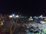
December 29th – It all went a bit Pete Tong. I left home late – the weather had again been dismal – in the dark, and had somewhere to be, and very limited time. Bereft of inspiration, I headed up to the A5. The wind and drizzle were vile, truly vile, and then I realised I’d forgotten my camera. This left me with the task of attempting night photography, without a tripod I could use, on a phone camera. Great.

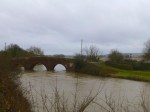
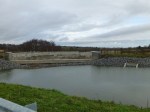
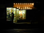
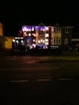
As it happened, it wasn’t too bad; I got reasonable results with the rail plant yard at Newtown, and some Christmas lights on a house near Deakin Avenue. Then home beckoned. I spotted the flood at the top of the Black Path too late. Wonderful.

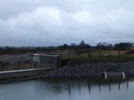
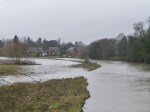
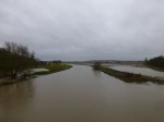
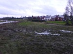
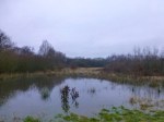
Actually, huge parts of Holland Park were under water. Is this rain ever going to stop? I returned home, sodden and grim, cursing my forgetfulness.

December 28th – Take one large pit mound. Leave it in the northwest corner of Chasewater, then landscape it. Plonk a bench on top. Then wait for a bored, bedraggled cyclist to pedal up it in the dark. 

Here, I experimented with long exposure photographs again. I was looking for something interesting, but the wind and rain were a problem. As I returned, I tried the same over the Swag pool, towards Norton.

None of these have been doctored, and exposures varied between 1.6 and 5 seconds. Quite pleased, really.

December 28th – Another grey, wet day. I’ve never known the weather quite so bad. I almost feel cheated out of my holiday – haven’t been on a single long, decent ride yet…

I spent a lot of time at Chasewater this afternoon. The weather was windy and squally, and the water level still increases. The last time I looked – Tuesday, Christmas day, it stood at 8cm on the lower scale. Since then, it’s recede 98cm on the upper scale. That’s a 10cm increase, another four inches. Just to tot that up, that’s 18 inches in 8 days and 24 inches – 2 feet – since december 16th, 12 days ago. That is one huge volume of water pouring into the feeders and watercourses that top up Chasewater. That’s one hell of a lot of rain. I’d say there’s only a couple of feet to go now, maybe less: The main lake is only an inch or so from joining with the Nine-foot through the new bridge.

Sorry to keep harping on, but this is historic stuff. I have never, ever experienced a season this wet.

December 26th – It was more like Christmas weather, really. It was sunny and clear when I headed out, and I enjoyed a bustling, crowded Chasewater. Heading to Lichfield, the rain arrived, and I spent a couple of hours testing my waterproofs. The, as quickly as it came, the rain stopped, the skies cleared and there was a respectable sunset. At Hints, the ford was tranquil in the dusk, and the ancient tumulus of Crow’s Castle made for an impressive silhouette.

December 26th – The dirty old river Tame that gives it’s name to Tamworth and doubles the Trent by draining Birmingham, was in impressive form yesterday. I’m interested in the flood pattern of this river, which runs in a natural channel from Minworth to Cat Holme, near the National Memorial Arboretum. heading out when the sun was shining, I looped through Lichfield and Whittington as the rains came. At Elford, I surveyed the path of the recent flood, and the houses on The Beck – which are so attractive in summer -looked vulnerable. The old Elford bridge, however, looked as steadfast as ever. Following the river down through Tamhorn, I viewed it again from Hopwas, where it’s natural flood channel can be seen. That shallow berm is more than enough to protect the houses of the village, as to the eastern side, the plain is wide. It’s interesting to note anti-erosion work going on there. 

The waters look brown, angry and filthy, and they currently are. Undoubtedly contaminated with all manner of pollutants, including possibly sewage, it will take a few dry weeks to settle before returning to it’s  clear, glass-like self. 

There’s no avoiding the spirit of the water.

December 25th – On the way to Castle Ring, weak sunshine mingled with sharp showers. As I was stood looking down at the power station, the air cleared and the view improved. On the embankment near the wood on Holly Hill Lane, a tine waterfall has developed., confirming my feeling that the whole forest seems absolutely saturated. As I left, I noted the view towards the Black Country from opposite the Park Gate Inn; I never realise you could see Dudley Castle from here…

December 25th – The weather cheered up for the traditional Christmas day ride, which was unexpected and enjoyable. Heading out along the dam at Chasewater, I succumbed to my OCD about the water level and took a picture of the scale. It really isn’t far now until the water reaches the maximum level of the top of the weir in the spillway. I reckon it might just get there by new year. I last checked last Thursday, 20th December, when the water was at 44cm from the top of the middle metre scale. It now stands at 8cm from top – an increase in 5 days of 36cm, or 14 inches. I have never seen anything like this. Water is now lapping around the balcony shore, and to all intents and purposes, is now at pre-dam work levels. A remarkable thing and a great Christmas present for all wildlife enthusiasts who love this special place.

December 24th – I cycled over a very grey, silent Chasewater at dusk to Morrisons in Burntwood. The supermarket was very quiet for 4pm on Christmas Eve, and I felt quid sad and un-Christmassy. To cheer myself up, I cycled back through Chasetown. I like this odd little hillside village, and it’s steeply inclined High Street. They have quite a good Christmas tree this year, and in the damp darkness, the lights of the traffic and shopfront mingled to form a very festive scene. I felt much better, and cycled home damp, but full of festive spirit once more.

Merry Christmas, everyone! 

December 24th – I reckon, if this weather continues, there won’t be any smokers left in the UK by the end of January. Everything in the country will just be too soggy to light….

I don’t think I’ve ever known such a wet Christmas break. Disappointing, as I wanted to get up to Derbyshire, or maybe just around Staffordshire, but largely I’m confined to utility rides around home at the moment. It was on such a ride today that I noted the canal  overflow at Brownhills had swamped it’s culvert again. That’s the second time in two months, and as a consequence, the low area of Clayhanger Common is starting to flood. This area, if the wet weather continues, will be several feet deep in a day or so, but it’s doing exactly what it was designed to do, and protecting Clayhanger Village and the Ford Brook channel from flooding.

In years gone by, this would have flooded the village, but since the reclamation of the common and the creation of this flood bund, the village is protected giving residents there peace of mind and a good Christmas.

Next time you see someone from the Environment Agency, tip your hat.

December 23rd – An evening return through Chasewater revealed, unsurprisingly, ever increasing water levels. I’m hoping the lake will be near full by new year, and by the state of the forecast, that looks distinctly possible. At the moment, I’m most interested in the waterline around the pier. After so long high and dry, I’m wondering how being soaked again in the water is affecting the structure, with let’s face it, was knackered a long time ago. I can’t figure out why it hasn’t actually been removed…