July 8th – Whittington is developing a bit of a reputation as an ecologically sound, green village. They hold ‘Green’ fairs here quite often, and there are food markets here at weekends. All of which are really, really good to see.

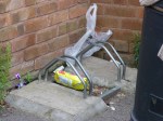
The effect, however, is somewhat spoiled for cyclists who choose to visit the local Co-op general store. The cycle parking, consisting of two wheel bender stands, have been concreted in too close to a wall to work for an adult bike. Even if they were not, the clothes bank and bin prevent you from using them.

Well done, folks. Next time, ask a cyclist first, eh?

May 7th – The odd symbol on this markerstone will be familiar to many who study old buildings, but it’s purpose is not widely understood. It’s a surveyor’s benchmark, used by Ordnance Survey mapmakers. The horizontal bar at the top of the mark indicates a known, measured height above mean sea level, which the surveyor will know and can then use to reference other measurements. Benchmarks can exist anywhere, but are easily spotted on churches, bridge abutments and stone gateposts. Sometimes, as in this case by the A51 near Whittington Golf Course, a stone is placed for the purpose. These are a secondary reference to trig points. It is actually an offence to remove or obscure one.

In the days of new technology such as global positioning and satellite imagery, benchmarks are not as commonly used as they once were, but every surveyor that works for the OS is still taught to carve them. They are a tangible, visible footprint of the gorgeous heritage of British map-making that the Ordnance Survey represents.